


Today we are on the Emilian side of the Ligurian Apennines, still on the border with the Aveto Park. Our route takes place largely through the beech forest, reaching the panoramic peak of Mount Trevine. If you wish, it is possible to complete the circular route in the Monte Penna forest. The trail is largely hiking, but has a difficulty level of EE in the small rocky area between Monte Pennino and Penna. It is not recommended to travel this area with wet rock or the presence of ice and snow.
We arrived at the starting square along the country road that goes from Santo Stefano d’Aveto to the Tomarlo pass. From here you take the detour to the Monte Penna forest. Once you reach Chiodo Pass, you descend from the Parma side towards Table Pass, to a clear clearing where the dirt road marked Faggio dei Tre Comuni begins.
But why is it called Faggio dei Tre Comuni?
In fact, the term Beech in these regions does not even mean a tree. It indicates the presence of a large beech forest that extends over the territory of the three neighboring municipalities: Bedonia, Santo Stefano d’Aveto and Borzonasca.


The Legend of the Two Sister Rivers
On the road that leads from Passo del Chiodo to Faggio dei Tre Comuni we can notice on the right a small rest area that shows the source of the Ceno Stream, the most important tributary of the Taro River. This is how this racing legend was born on these ridges.
“Between the rocky cliffs of Monte Penna, as if inside a stone rock, one day two Argentine springs suddenly emerge. And then, as soon as the brow was filled with the fresh gurgling, the two brothers resolved to part, and each to take his own path, down the marked valleys, to meet at Fornovo. Whoever arrived first would give a name to the river, which from Fornovo, crossing the plain, was to reach the Po.
In the evening, when the moon was imminent in Penna, the two brothers had to leave each other and go their separate ways. While Ceno slept soundly, in the coolness of his cradle, Taro, gathering in the veins of the earth all the force of the trembling waters, suddenly, silently, and secretly, without his brother perceiving it, begins to run down his steep valley. When the moon shines on Penna, Shino wakes up and searches in vain for his brother Taro near him, who was already thundering in the ravines and rocks of the mountain.
In vain the Ceno runs, runs, and with trembling foam leaps and leaps in the valley, for when he reaches Fornovo, and just as dawn has dawned in the east, the Taro, spread with great shining blades on the bed of the river, was already running towards the mouth of the Po.”
(Francesco Zanetti 1870-1938)
Mount Trevin
From the widening dirt road we walk along the cart track to the Faggio dei Tre Comuni refuge at an altitude of 1400 m. Here you take the path marked by the white-red sign 871. You proceed diagonally through the beech forest that covers the southern slope of Mount Trevine , scattered with large boulders and small flat clearings where coal pits once stood. After two hairpins, continue diagonally until the path heads north, approaching a stream, which you cross a little further down by bending to the left.
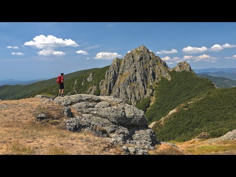
From here we continue without changing direction to the upper end of the long face of the rock that forms the northern side of Mount Trevine. Walking a few meters from the top, you reach the grassy summit of the mountain at an altitude of 1661 m where you can admire the magnificent view of the rocky eastern slope of Monte Penna.


Anyone who wants to can retrace their steps, otherwise continue taking a small gully between the rocks and diagonally across the grassy crest until you re-enter the forest. With the help of the trail sign, continue the path, often reduced to a light track, to a gap in rocks where you meet the trail sign solid yellow triangle from Penna Barracks. Follow the signs to the left until Forcella del Pena where the exposed stretch leading to the summit begins Monte Penna (1735m). From here follow the footpath signs to the west which lead to Incisa pass where you follow the dirt road to the left. After a long flat stretch, the road descends with two bends towards the springs of Taro, and then continues flat towards its slopes Monte Crociato. Turning north, it reaches the Faggio dei Tre Comuni, 4.5 km from the Incisa pass.